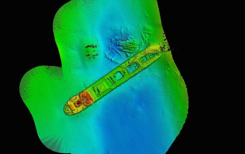
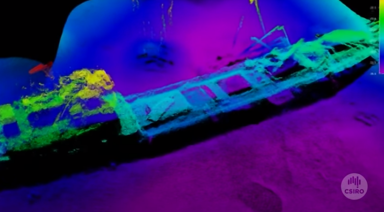
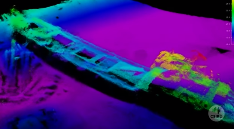
Australian researchers have used some new sonar equipment to capture stunning imagery of the shipwreck of the MV Lake Illawarra bulk carrier, which tragically sank in Hobart’s Darwent River in what is now remembered as the Tasman Bridge Disaster.
On the night of 5 January 1975, the 10,000 dwt MV Lake Illawarra struck a piling of the Tasman Bridge, causing a 127 meter span of the bridge to collapse on top of the vessel and sink it. Tragically, seven crewmembers onboard the vessel and five motorists lost their lives in the disaster, and the loss of the bridge essentially severed the link between Hobart and its eastern suburbs for years until it was fixed. The wreck of the Lake Illawarra now lies in 34 meters of water on the southern side of the new Tasman Bridge.
To map the wreck, a team of researchers from Australia’s Commonwealth Scientific and Industrial Research Oganisation used its new EM2040c, a high resolution multibeam echo sounder from Kongsberg. Not surprisingly, the imagery it returned was fascinating, and also slightly eerie.
The Kongsberg EM2040c is a shallow water sonar that is able to map the sea floor up to 500 meters and designed with mobility in mind, so that it can be lifted by a single person and fit on almost any vessel. The system generates a fan shaped acoustic beam called a swath, which can be up to four times the water depth in width. It is able to send and receive signals at a rate of 50 times per second.
Kongsberg says that the EM 2040C ensures that highly accurate data is available in real-time, making it possible to conduct very cost-effective surveys with lower requirements for post-processing, due to the high quality of data available.
The mapping of the Lake Illawarra took about an hour.
CAIRO, March 2 (Reuters) – The Houthi Transport Ministry in Yemen said on Saturday there had been a “glitch” in undersea communication cables in the Red Sea as a result of actions...
by Captain John Konrad (gCaptain) In the current American labor landscape, the stark contrast between the assertive strides of transportation unions and the maritime sector’s unique labor challenges is striking....
By Mikhail Flores MANILA, Dec 2 (Reuters) – Evacuations were under way in the Philippines after a quake of at least magnitude 7.5 struck the southern region of Mindanao on Saturday night,...
December 2, 2023
Total Views: 2164
Why Join the gCaptain Club?
Access exclusive insights, engage in vibrant discussions, and gain perspectives from our CEO.
This website uses cookies to improve your experience while you navigate through the website. Out of these, the cookies that are categorized as necessary are stored on your browser as they are essential for the working of basic functionalities of the website. We also use third-party cookies that help us analyze and understand how you use this website. These cookies will be stored in your browser only with your consent. You also have the option to opt-out of these cookies. But opting out of some of these cookies may affect your browsing experience.
Necessary cookies are absolutely essential for the website to function properly. This category only includes cookies that ensures basic functionalities and security features of the website. These cookies do not store any personal information.
Any cookies that may not be particularly necessary for the website to function and is used specifically to collect user personal data via analytics, ads, other embedded contents are termed as non-necessary cookies. It is mandatory to procure user consent prior to running these cookies on your website.

 Join The Club


![A screengrab of a map showing an earthquake Mindanao, Philippines on Dec 2, 2023. (Image: US Geological Survey [USGS])](https://gcaptain.com/wp-content/uploads/2023/12/Screenshot-2023-12-02-at-10.45.17-AM-copy.png.webp)


