
 Join The Club


News
Iranian Ship Linked to Houthi Attacks Heads Home Amid Tensions
(Bloomberg) — An Iranian ship that’s been linked to Houthi attacks in the Red Sea is returning home, removing a prominent asset in the area as the Islamic Republic braces...
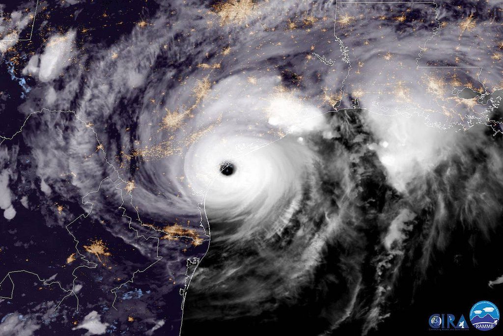
Captured by the GOES-16 satellite on August 25, 2017 at 23:00 UTC, this image shows Hurricane Harvey as it reaches peak intensity of Category 4 with maximum sustained winds of 130 mph.
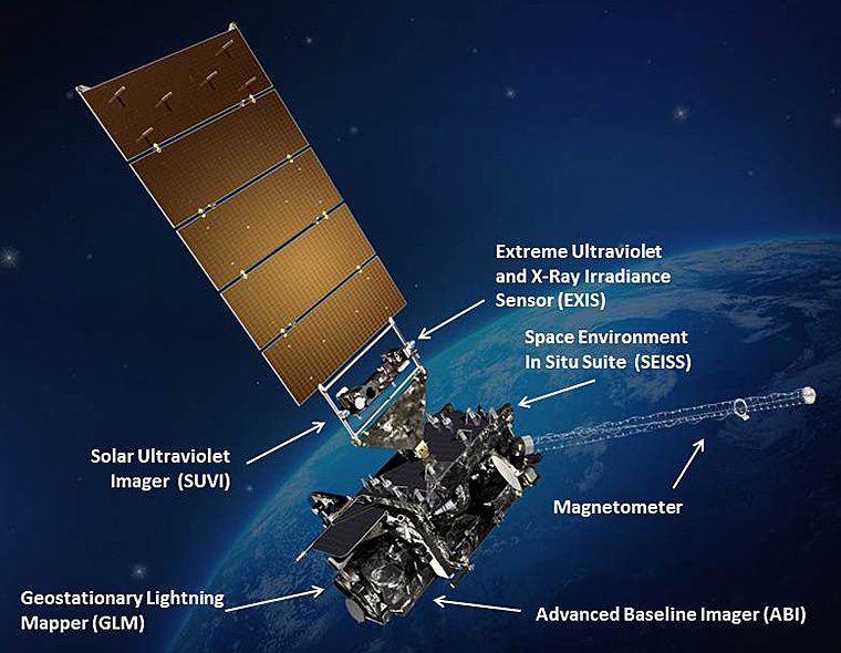
The U.S. The U.S. National Oceanic and Atmospheric Administration’s next-generation geostationary weather satellite known as GOES-16 is now officially operational after moving into its new GOES-East position, where it will observe weather and provide critical data to forecasters from more than 22,000 miles above the earth’s atmosphere.
Since its launch in November 2016, the GOES-16, even in its testing phase, already proved vital for forecasters and emergency managers during 2017’s active hurricane season.
Now in its operational orbit at 75.2 degrees west longitude (the GOES East position), it is ready to give forecasters with sharper, more defined images of severe storms, hurricanes, wildfires and other weather hazards in near real-time, and cover a region including the West Coast of Africa, the central Atlantic Ocean, and the continental United States.
“GOES-16 has proven to be one of the most important tools we’ve ever developed for our weather and hazard forecasts,” said retired Navy Rear Adm. Timothy Gallaudet, Ph.D., acting NOAA administrator. “From its impressive first image of Earth last January to monitoring tropical storms and wildfires, GOES-16 has and will continue to greatly improve our ability to visualize potential threats, and enhance forecasts and warnings to save lives and protect property.”
Already, GOES-16 provided critical data which aided in emergency preparedness during this year’s extremely active hurricane season, delivering experimental imagery with detail and clarity never before achieved with existing satellites. Its high resolution – four times higher than previous NOAA satellites – and views of Earth taken every 30 seconds allowed forecasters to monitor how and when storms developed.
Data from GOES-16 also allowed forecasters to better assess and predict how much rain Hurricane Harvey would produce over Texas and see its rapid intensification, along with hurricanes Irma, Jose, and Maria.

In addition to hurricanes, GOES-16 data helped monitor and detect wildfires, and gave forecasters detailed images of wildfire smoke, enhancing their air quality forecasts. Imagery from GOES-16 helped forecasters spot new wildfires in California, Kansas, Oklahoma, and Texas, and determine which fires were hottest and where the fires were spreading.
NOAA’s #GOES16 shows #wildfires (in Geo & Natural Fire Color) raging in parts of #California yesterday. More loops: https://t.co/8l5NGSMGLx pic.twitter.com/WKXhLgorcf
— NOAA Satellites (@NOAASatellites) October 10, 2017
GOES-16 testing showed potential improvements for aviation weather forecasting and airport operations. Forecasters are now able to predict with greater accuracy than before when fog and clouds will form and clear. The new satellite can also detect turbulence, enabling forecasters to issue timely advisories, aiding in aircraft and passenger safety.
NEW #GOES16 now #GOESEast tech – Global #Lightning Mapper will soon provide real-time convective weather data to aviation forecasters – this imagery shows how flights (red dots) are safely routed around (or through!) a weather system. @LockheedMartin #TheFutureIsBright pic.twitter.com/zKZMLO9l2T
— NOAA Satellites (@NOAASatellites) December 20, 2017
“We are using the GOES-16 data in ways we planned and in ways we didn’t even imagine,” said National Weather Service director Louis Uccellini, Ph.D. “GOES-16 has been a game changer for monitoring hurricanes, wildfires, severe storms, and lightning. Now that it is operational and the data is incorporated into the forecast process, we will be able to use it across all our service areas, starting with winter storms.”
Data from GOES-16 has been available to NOAA forecasters and the national and international weather modeling and forecasting community during the satellite’s testing phase and will continue to be made available.
GOES-16 is the first in the series of next-generation geostationary satellites. The next new NOAA satellite, GOES-S is scheduled to launch March 1, 2018 followed by GOES-T in 2020 and GOES-U in 2024.
Join the gCaptain Club for curated content, insider opinions, and vibrant community discussions.
Join the 105,979 members that receive our newsletter.
Have a news tip? Let us know.
(Bloomberg) — An Iranian ship that’s been linked to Houthi attacks in the Red Sea is returning home, removing a prominent asset in the area as the Islamic Republic braces...

COPENHAGEN, April 15 (Reuters) – Shipping company Maersk has not made any deployment changes after a Portuguese-flagged container ship was seized by Iran in the Strait of Hormuz on Saturday, the Danish company said on Monday. “We find recent...

WASHINGTON, April 15 (Reuters) – The FBI has opened a federal criminal investigation into the deadly collapse of a Baltimore bridge last month when a ship crashed into one of its supports,...


Access exclusive insights, engage in vibrant discussions, and gain perspectives from our CEO.
Sign Up

Maritime and offshore news trusted by our 105,979 members delivered daily straight to your inbox.
Essential news coupled with the finest maritime content sourced from across the globe.
Sign Up
