Tsunami Event – October 25, 2010 Mentawai, Indonesia
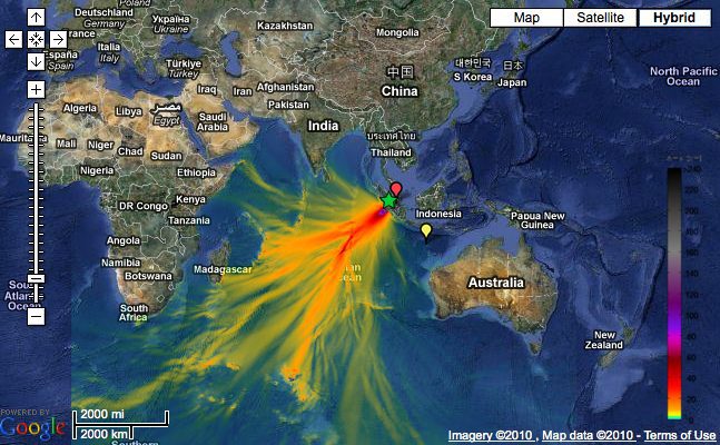
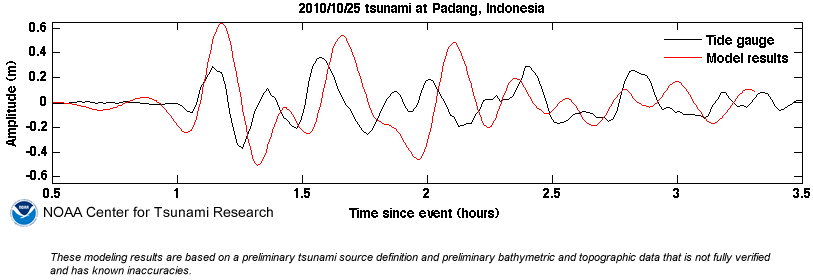
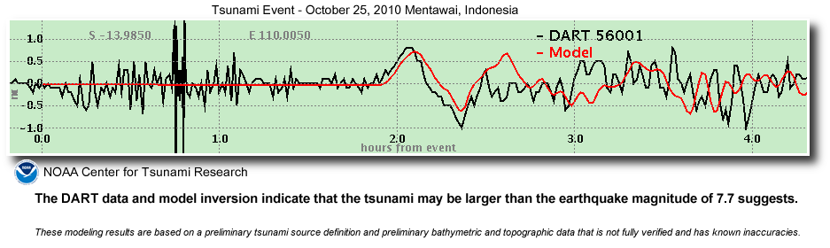
The Indonesia tsunami event was generated by a Mw 7.7 earthquake (3.484°S, 100.114°E ), at 14:42:22 UTC, 240 km (150 miles) W of Bengkulu, Sumatra, Indonesia (according to the USGS). In a little under 2 hours, the tsunami was first recorded at DART® buoy 56001 and in a little under 3 hours, the tsunami was recorded at DART® buoy 56003. Forecast results shown below were created with the NOAA forecast method using MOST model with the tsunami source inferred from DART® data. The tsunami waves first arrived at Padang (approximately 270 Km from the earthquake epicenter ), at 15:47 UTC, about 65 minutes after the earthquake. The DART data and model inversion indicate that the tsunami may be larger than the earthquake magnitude of 7.7 suggests.
NOAA-Today, following input from tribal nations, state and federal agencies, Indigenous communities, and the public, NOAA released a proposal to designate a 5,617-square-mile area offshore of San Luis Obispo and...
by John Konrad (gCaptain) In the realm of seafaring, mariners maintain a keen eye on two things: weather and the maps that guide them safely through unknown waters. These nautical...
By Nathan Frandino and Daniel Trotta SAN FRANCISCO, June 29 (Reuters) – Gray whales on the North American Pacific coast fell this year to their lowest population since the late 1960s and...
July 2, 2023
Total Views: 2103
Why Join the gCaptain Club?
Access exclusive insights, engage in vibrant discussions, and gain perspectives from our CEO.
This website uses cookies to improve your experience while you navigate through the website. Out of these, the cookies that are categorized as necessary are stored on your browser as they are essential for the working of basic functionalities of the website. We also use third-party cookies that help us analyze and understand how you use this website. These cookies will be stored in your browser only with your consent. You also have the option to opt-out of these cookies. But opting out of some of these cookies may affect your browsing experience.
Necessary cookies are absolutely essential for the website to function properly. This category only includes cookies that ensures basic functionalities and security features of the website. These cookies do not store any personal information.
Any cookies that may not be particularly necessary for the website to function and is used specifically to collect user personal data via analytics, ads, other embedded contents are termed as non-necessary cookies. It is mandatory to procure user consent prior to running these cookies on your website.

 Join The Club


