The Exploratorium brings us live earthquake monitor and mapping links! Normally I wouldn’t cut an paste so much info but in light of messages I’ve received from mariners worried about their families, here it is:
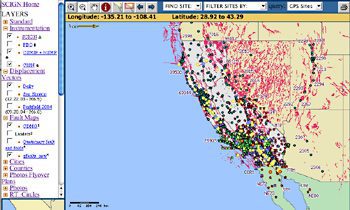
Southern California Integrated GPS Network Mapsurfer
Mapsurferer is an interactive mapping system that allows visitors to overlay different layers of information on a map of California. These layers include seismic stations, highways, geological features, major faults, and more. While information about the Bay Area and northern California is available, this map focuses on southern parts of the state.
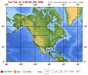
Quakes in the last 7 days: USGS Earthquake Hazards Program
The USGS has many maps of live earthquake data. This section lets visitors see quakes that have occurred anywhere in the world in the last week. You can also focus on geographic regions. Zooming in to a specific quake, you reach a page with specific data and links to the area’s seimic and quake damage history
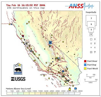
Shake map of California and Nevada showing fault lines
These maps are nice illustrations of the fact that earthquakes occur along faults. You can click the small boxes to zoom in and get more details on specific quakes
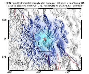
Did you feel it?
Seismometers can measure shaking, but how much does that reflect what people actually feel? On this site, people in the area of a quake can report their experiences to the USGS, and the results are made into a map. This can be compared with other shake maps for the same quake that were generated from seismometer data.
IRIS Seismic Monitor
IRIS (Incorporated Research Institutions for Seismology) has developed their Seismic Monitor that offers data about quake in near realtime, lets you search the Web for information about them, and view seismograms.
Real-time seismograms
Recorded by stations in the Northern California Seismic Network, these seismograms update every 5 minutes. The site also includes information on interpreting seismograms and examples of different magnitudes.
USGS Global Positioning System (GPS) monitors
USGS keeps many live earthquake monitoring stations that track movements of the earth’s plates using GPS. Because plate movement is fairly slow, the data are recorded over long periods of time. So the information on this site records events in the last year, or last decade, rather than the last week.
The 2024 Atlantic hurricane season is expected to be exceptionally active, according to researchers at Colorado State University. In their initial forecast, they predict 11 hurricanes, marking the highest prediction...
By Yimou Lee TAIPEI, March 7 (Reuters) – China has stepped up grey-zone warfare against Taiwan, aiming to make the areas around the democratic island “saturated” with balloons, drones and civilian boats,...
Austal USA has kicked off plans to construct a new manufacturing facility, marking a significant expansion of its shipyard capacity in Mobile, Alabama in support of U.S. Navy and Coast...
February 6, 2024
Total Views: 1756
Why Join the gCaptain Club?
Access exclusive insights, engage in vibrant discussions, and gain perspectives from our CEO.
This website uses cookies to improve your experience while you navigate through the website. Out of these, the cookies that are categorized as necessary are stored on your browser as they are essential for the working of basic functionalities of the website. We also use third-party cookies that help us analyze and understand how you use this website. These cookies will be stored in your browser only with your consent. You also have the option to opt-out of these cookies. But opting out of some of these cookies may affect your browsing experience.
Necessary cookies are absolutely essential for the website to function properly. This category only includes cookies that ensures basic functionalities and security features of the website. These cookies do not store any personal information.
Any cookies that may not be particularly necessary for the website to function and is used specifically to collect user personal data via analytics, ads, other embedded contents are termed as non-necessary cookies. It is mandatory to procure user consent prior to running these cookies on your website.

 Join The Club