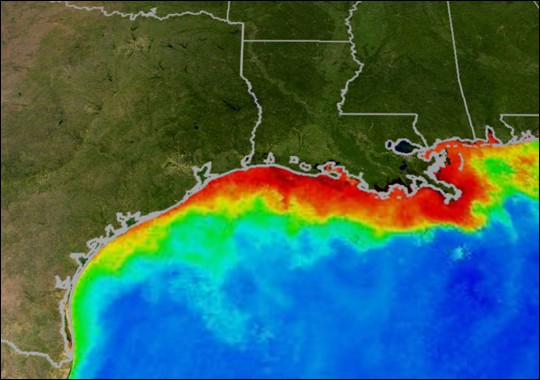
NOAA MAp of The Gulf Of Mexico Fisheries Dead Zone
A team of NOAA-supported scientists is predicting that this year’s Gulf of Mexico hypoxic zone could range from a low of approximately 1,197 square miles to as much as 6,213 square miles. The wide range is the result of using two different forecast models based on Mississippi River nutrient surveys.
The smaller dead zone forecast, covering an area slightly larger than the state of Rhode Island, comes from researchers from the University of Michigan. Their predicted size is based solely on the current year’s spring nutrient inputs from the Mississippi River which are significantly lower than average due to drought conditions throughout much of the watershed.
The larger dead zone forecast, about the size of Connecticut, is from Louisiana Universities Marine Consortium and Louisiana State University scientists. The Louisiana forecast model includes prior year’s nutrient inputs which can remain in bottom sediments and be recycled the following year. Last year’s flood, followed by this year’s low flows, increased the influence of this “carryover effect” on the second model’s prediction.
Hypoxia is caused by excessive nutrient pollution from human activities coupled with other factors that deplete the oxygen required to support most marine life in bottom and near-bottom water.
During May 2012, stream flow in the Mississippi and Atchafalaya rivers were nearly half that of normal conditions. This resulted in a decrease in the amount of nitrogen transported by the rivers into the Gulf. According to USGS estimates, 58,100 metric tons of nitrogen (in the form of nitrite plus nitrate) were transported in May 2012 by the Mississippi and Atchafalaya Rivers to the northern Gulf. The amount of nitrogen transported to the Gulf in May 2012 was 56 percent lower than average May nitrogen loads estimated in the last 33 years.
The two smallest recorded dead zones to date are in 2000 when it measured 1,696 square miles and a 15 square miles dead zone in 1988. Last year’s dead zone measured 6,765 square miles. The largest hypoxic zone measured to date occurred in 2002 encompassing more than 8,400 square miles.
“These forecasts are the product of decades of research, monitoring, and modeling on how decisions we make in the vast drainage basin of the Mississippi and its tributaries translates into the health of the coastal zone of the Gulf of Mexico,” said USGS Director Marcia McNutt, Ph.D.
The hypoxic zone, that form each spring and summer off the coast of Louisiana and Texas, threaten commercial and recreational Gulf fisheries. In 2009, the dockside value of commercial fisheries in the Gulf was $629 million. Nearly three million recreational fishers further contributed about $10 billion to the Gulf economy, taking 22 million fishing trips
Unlock Exclusive Insights Today!
Join the gCaptain Club for curated content, insider opinions, and vibrant community discussions.

 Join The Club