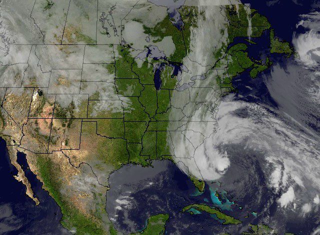
“Frankenstorm” on Oct. 27. Image: NASA
(Bloomberg) — The superstorm expected to develop from Hurricane Sandy is moving northward toward the U.S. Atlantic coast and may bring high winds and rain that could inundate coastal areas along with the tidal surge.
The system, which has killed as many as 43 people, remained on track to hit the region sometime late on Oct. 29 or early Oct. 30.
Power to millions of people may be cut for as long as a week, and airplanes grounded. The cyclone, dubbed “Frankenstorm” by the National Weather Service, will grow out of Sandy and two other storms rushing eastward across the U.S., said Tom Kines, a senior meteorologist at AccuWeather Inc. in State College, Pennsylvania.
“There is going to be a lot of rain and wind damage,” said Dan Pydynowski, a meteorologist with AccuWeather Inc., in a telephone interview. “This is going to be a much larger, more widespread storm than Hurricane Irene.”
The National Guard and Air Force put as many as 45,000 personnel in seven states on alert for possible duty in response to the storm, according to George Little, a spokesman for the Defense Department in Washington. Across the Caribbean, as many as 43 people were killed when Sandy crossed at hurricane strength, the Associated Press reported.
Giant Storm
“Because of the large size of the system and the slow motion, it’s going to be a long-lasting event, two to three days of impacts for a lot of people,” said James Franklin, branch chief at the National Hurricane Center in Miami. “The kinds of things we are looking at ultimately would be wind damage, widespread power outages, heavy rainfall, inland flooding and again, somebody is going to get a significant surge event out of this.”
Sandy is expected to be so large it will cover the eastern third of the U.S., said Louis Uccellini, director of the National Centers for Environmental Protection in College Park, Maryland. The storm’s reach may extend into southern Ontario, Quebec and the Maritime provinces, according to a bulletin from Environment Canada.
Uccellini said he didn’t want to predict where Sandy, which now has a 90 percent chance of striking the U.S., will rank in terms of the largest storms to hit the Northeast until he sees how it develops.
100 Years
Paul Kocin, a National Weather Service meteorologist in College Park, said if Sandy grows as expected, it may be the worst storm to hit the region in 100 years.
“What we’re seeing in some of our models is a storm at an intensity that we have not seen in this part of the country in the past century,” Kocin said in a telephone interview. “We’re not trying to hype it, this is what we’re seeing in some of our models. It may come in weaker.”
Sandy’s maximum sustained winds remained unchanged at 75 miles per hour (120 kilometers), the hurricane center said in an advisory about 11 a.m. New York time. It was centered 190 miles north-northeast of Great Abaco Island in the Bahamas and 355 miles southeast of Charleston, South Carolina, moving north- northeast at 9 mph.
The center’s three-day forecast shows that Sandy will come ashore late Oct. 29 or early Oct. 30 along the coast from Chesapeake Bay to outer Long Island, probably in the Delaware Bay area. The path may change before landfall, the center said.
Lunar Tides
New Jersey Governor Chris Christie declared a state of emergency today, and ordered the state’s barrier islands and casinos in Atlantic City be evacuated by 4 p.m. Sunday.
The storm may dump as much as 12 inches (30 centimeters) of rain on parts of the Northeast, the center said. The damage will be spread across a wider area than that left by a typical hurricane, Franklin said.
“Our track forecast error is on the order of 150 to 200 miles,” Franklin said. “We cannot be precise at this stage.”
Franklin said the storm surge, or ocean water the storm pushes into the shore, will hit a larger area than Hurricane Irene last year. The storm will also be striking two days after the full moon when tides are at their highest.
“The lunar tides, this is a dangerous period,” Uccellini said. “And with the slow movement of the storm you can go through two or three tidal cycles, which also contributes to the potential impact of this event.”
Snow
Uccellini said there is the potential for at least 12 inches of snow in West Virginia and lesser amounts in Pennsylvania and eastern Ohio. The system will probably drift back to the northeast and into New England while weakening, he said.
Power may be out as long as 10 days in some areas, according to a statement from the Edison Electric Institute, an industry trade group in Washington.
The storm may cause hardship for thousands, especially those that get hit by the snow and also lose power, said Mark Hoekzema, chief meteorologist at Earth Networks in Germantown, Maryland.
“Are you ready to potentially be without power for a week?” Hoekzema said by telephone. The windstorm that hit the Washington area in June “showed us how long it can take to get 3-plus-million people back, and in the Northeast Corridor you have even more people,” he said.
Discussions are under way to evacuate parts of New York City and close subways if necessary, said Jerome Hauer, New York State’s homeland security commissioner.
Worst-Case Scenario
“The worst-case scenario is that the storm hits in the mid-Jersey area, with the right-sided winds,” Hauer said in an interview. “That forces water in the ocean into New York Harbor and we get significant flooding in New York City, particularly in lower Manhattan, Brooklyn and Queens.”
Sandy’s approach to the Northeast will probably start disrupting air travel tomorrow as airlines move aircraft out of its way, Hoekzema said. He said he expects railroads will also be affected by trees falling on the tracks and power lines being knocked down.
Amtrak’s Acela and Northeast regional trains run off overhead power lines between Washington and Boston. The passenger railroad said it was monitoring the storm.
“There is going to be a significant disruption of pretty much everything from supply chains to travel for most of next week,” Hoekzema said.
Hybrid System
Sandy’s apparent weakening doesn’t accurately predict the storm it may become, said Matt Rogers, president of Commodity Weather Group LLC in Bethesda, Maryland. Computer models suggest the hurricane may transform into a hybrid system over the weekend because of another storm moving in from the Midwest.
“When the storm phases with the energy from the west, it is forecast to deepen rapidly,” Rogers said. “Indeed, it is expected to continue weakening until phasing really takes place late Sunday into early Monday.”
Rogers said the barometric pressure may fall lower than when Sandy was a hurricane in the Caribbean. The lower the pressure, the stronger the storm.
Virginia Governor Bob McDonnell and Maryland Governor Martin O’Malley declared states of emergency ahead of the storm.
The system crossed Jamaica Oct. 24 and Cuba on Oct. 25, tracking north across the central Bahamas.
The U.K.’s Press Association reported that Timothy Fraser- Smith, chief executive officer of Deltec Bank & Trust Ltd., died when he fell from the roof of his home on Oct. 25. In Haiti, the AP said some people died there trying to cross rivers that were swollen by rains.
Sandy may have caused $1.4 billion to $2.4 billion in damage on Cuba, Jamaica and the Bahamas, according to Air Worldwide, a catastrophe-modeling firm in Boston. Dozens of airline flights in and out of the region were canceled.
-By Brian K. Sullivan. Copyright 2012 Bloomberg.
Unlock Exclusive Insights Today!
Join the gCaptain Club for curated content, insider opinions, and vibrant community discussions.

 Join The Club