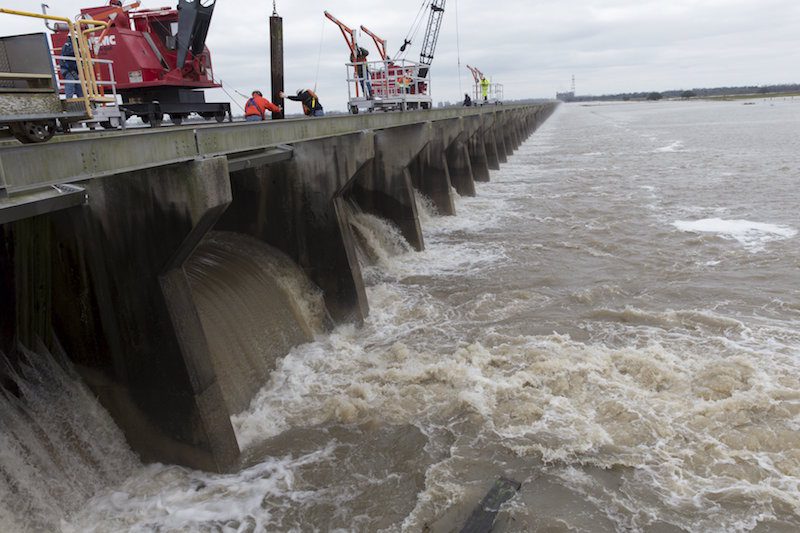
Workers open the Bonnet Carre Spillway in Norco, Louisiana, January 10, 2016. The United states Army Corps of Engineers decided to open the spillway to relieve high water levels in the Mississippi River. REUTERS/Lee Celano
By Tim Loh
(Bloomberg) — The threat of flooding is subsiding across the lower Mississippi River region just two weeks after high waters devastated parts of the St. Louis area.
The Mississippi probably won’t rise as high from Arkansas to New Orleans as earlier forecasts projected, according to the National Weather Service.
“Crest heights are going to be a bit less than what we were looking at last week, which is good news,” said Jeffrey Graschel, a hydrologist at the Lower Mississippi River Forecast Center, an arm of the weather service, in Slidell, Louisiana. “The levee system is working as it’s supposed to.”
Heavy rains late last year across the Midwest created the region’s worst flooding since 2011, deluging communities, forcing the closing of pipelines, terminals and grain elevators and killing at least 30 people, according to state emergency officials in Missouri, Illinois and Oklahoma.
The bulge of water has arrived in Arkansas City, Arkansas. It will probably crest in Baton Rouge on Jan. 18 at 43.5 feet (13 meters), about 8.5 feet above flood stage but beneath the 47.3-foot record set in 1927 and the 45 feet of 2011, according to Graschel.
High-Water Advisory
A high-water safety advisory remains in effect from Caruthersville, Missouri, to Natchez, Mississippi, the Coast Guard said. The Bonnet Carre anchorage is closed on the Mississippi River near New Orleans and the Port of Morgan City has closed Bayou Chene to all marine traffic.
On Sunday, the U.S. Army Corps of Engineers opened the Bonnet Carre Spillway near New Orleans for just the 11th time since 1931, Jeff Masters, co-founder of Weather Underground in Ann Arbor, Michigan, said on his blog. The spillway can divert as much as 250,000 cubic feet per second of water into Lake Pontchartrain, north of the city. Because of that, the river is already near its projected crest of 17 feet at New Orleans, Graschel said.
While it probably won’t be necessary to open other spillways, that doesn’t mean communities along the lower Mississippi have nothing to worry about, Graschel said.
“We do have high elevated waters right now, so rainfall will play a huge role in determining any additional flooding we could get in the future,” he said.
©2016 Bloomberg News
Unlock Exclusive Insights Today!
Join the gCaptain Club for curated content, insider opinions, and vibrant community discussions.

 Join The Club