Reaching from Chile up to the Bering Sea, then down again to New Zealand, the fault lines circling the Pacific Ocean are named The Pacific Ring of Fire and are collectively responsible for many fo the world’s most devastating earthquakes. The most infamous of these faults, at least for residents of the United States, is California’s San Andrea fault, a continental strike-slip that runs a length of roughly 810 miles along the California coast. But little is known about the geology of faults far below the earth’s surface.
In 2002, scientists in Parkfield California took the first steps to better understand earthquakes by drilling deep into the San Andreas Fault Zone to install instruments near the initiation point of previous high magnitude quakes. This experiment was followed in 2004 when a second hole was drilled reaching a depth of 3.4 kilometers below the surface.
While this experiment proved effective, it’s location was less than ideal. First, being landbased, 100% of the drilling depth was through the earth’s surface, limiting the total depth of the experiment. Offshore drilling operations often reach greater depth because, being in the water, up to the first 10,000 feet of depth does not require any drilling. Second, the last magnitude 6 earthquake at the site was recorded in 1966, too long ago for optimal results.
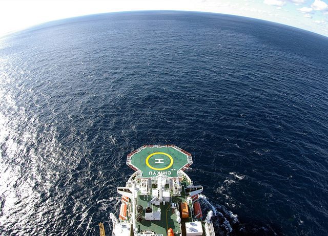
In January 2005, with drilling on the San Andreas fault near completion, scientists on the other side of the ocean took delivery of a groundbreaking ship built to address the shortcomings of Parkfield. Costing nearly $1 billion dollars, the drillship named Chikyu, the Japanese word for “Earth”, was designed to bore through the mantle of its namesake to explore the inner workings of earthquakes at depth.
And the vessel was impressive.
The enormous price tag of the 689-foot-long ship included scientific labratories, dynamic positioning systems, seven 12.5-foot-propeller thrusters, and a cruising speed of 12 knots.
Pure drilling science wasn’t its only goal however. Built in Nagasaki, a city known for the devastation science can design, the ship was built to use science as a means to protect Japan from another historic enemy, the tsunami. This destructive natural enemy was one that Parkfield – located approximately 40 miles inland from the coast, was incapable of measuring.
The Chikyu began drilling operations in 2007 with plans to prod the earth with six holes in regions of high seismic activity. But the Earth fought back. Trouble began for the Ckikyu early in the planned operation with the deepest hole reaching a depth of only 1,400 metres, far short of the planned depth of 6 kilometers. Minor setbacks continued to burden the operation, however by December 2010, the team was announcing it’s first major success. This announcement came with the installation of a long-term observatory which was planned to eventually connect to DONET, Japan’s network of oceanographic Tsunami warning systems.
With a break in the drilling program, the ship returned to Hachinohe, on the northeastern portion of Honshu – Japan’s largest island.
Then disaster struck.
On March 11, 2011, Chikyu recieved reports of an enourmous earthquake and quickly left port, but she was not fast enough. Just 300 meters from the shore when the wave hit, she was overcome by its forces and soon drifted into a pier damaging one of her enourmous thrusters. All personnel aboard the ship were safe, however like the seafloor in which she drilled, she was punctured. A damage survey revealed a 1.5 meter hole in the bottom of her hull.
Mitsubishi Heavy Industries, the company who originally outfitted the vessel, moved quickly to help begin repairs at their Yokohama shipyard. The timeline of repairs were critical because, though disastrous, the massive tsunami created an unparalleled opportunity to drill deep into a recently active fault. The scientific rewards could be unprecedented. The shipyard worked fast and on June 18th, the vessel returned to sea and the crew began preparations to drill into the epicenter of the earthquake which damaged their vessel.
The main question scientists now look to answer is how earthquakes form and how can detection methods be improved.
“It’s a fundamental issue in seismology right now: how do you get rock to slip tens of metres?”
James Mori, a seismologist at the Disaster Prevention Research Institute of Kyoto University in Japan, recently told Nature magazine. The answer may be in the resistance between plates of rock, resistance which creates heat. “Friction is dissipated as heat, precise temperature data should fill a crucial knowledge gap” said Mori.
To measure temperature, speed is essential.
Soon after the 1995 Kobe earthquake in Japan, experiments were conducted to measure the temperature of fault lines, however these projects largely failed, recording only the smallest temperature differences between long dormant and recently active faults. The question has remained if the lack of temperature differences is because of rapid cooling, negligible temperatures created by quakes, or because of imperfect monitoring techniques. “The recurring theme is that the faults tend to be colder than they should be,” says Emily Brodsky, a seismic reasearcher at the University of California noting that larger slip event provides a better chance of tracking the temperature increase. But to measure a “larger slip” you need a large earthquake, and the drilling apparatus available to measure the temperature of the fault at its core. “We need to do this now, and do it fast, and do it correctly.” said Brodsky.
The Chikyu may just the answer. Nature tells us she will drill down 1 kilometer through the fault, and lower a string of temperature sensors down the hole. By tracking temperatures for one to three years — much longer than has been attempted before — researchers should be able to calculate the total amount of heat that was generated by the quake. That will provide them with the resistance forces felt in the fault during the slip, filling in a blank in models of earthquake dynamics. “This is a key missing ingredient,” said Jean-Philippe Avouac, a geologist at the California Institute of Technology in Pasadena, who is not involved in the project.
Completing the drilling won’t be easy. The Tohoku fault lies under 7 kilometers of water, and some 700 meters of Earth’s crust, so a huge drill string will be needed. Previously, only a tiny 15-meter core has ever been extracted from beneath water of that depth, says Brodsky; most cores are taken from beneath 6 kilometers of water or less.
In addition to temperature measurements, the project will also examine the sediments pulled up in the core. Certain sediment textures, such as ball-bearing-like particles of clay, might be associated with large-slip earthquakes. Identifying such features should help scientists to forecast the slip potential of other faults.
The chance to collect precious information from the Tohoku event represents “an opportunity, maybe even a responsibility”, says Mori. Almost all of the damage caused by the quake was done by the tsunami, he points out. “What we really want to understand is what caused that.”
April 19 (Reuters) – A New York state agency on Friday said it had failed to reach final contract agreements with the developers of three major offshore wind projects, blaming a decision by General...
The Department of the Interior has announced a new rule aiming to ensure that costs related to the decommissioning of offshore platforms are covered by the oil and gas industry,...
(Bloomberg) — For a company that made its name with frontier oil discoveries from Iran to Alaska, BP Plc is notably absent from today’s hottest new oil plays. The company’s...
April 16, 2024
Total Views: 975
Why Join the gCaptain Club?
Access exclusive insights, engage in vibrant discussions, and gain perspectives from our CEO.
This website uses cookies to improve your experience while you navigate through the website. Out of these, the cookies that are categorized as necessary are stored on your browser as they are essential for the working of basic functionalities of the website. We also use third-party cookies that help us analyze and understand how you use this website. These cookies will be stored in your browser only with your consent. You also have the option to opt-out of these cookies. But opting out of some of these cookies may affect your browsing experience.
Necessary cookies are absolutely essential for the website to function properly. This category only includes cookies that ensures basic functionalities and security features of the website. These cookies do not store any personal information.
Any cookies that may not be particularly necessary for the website to function and is used specifically to collect user personal data via analytics, ads, other embedded contents are termed as non-necessary cookies. It is mandatory to procure user consent prior to running these cookies on your website.

 Join The Club