The Bureau of Safety and Environmental Enforcement (BSEE) and the National Oceanic and Atmospheric Administration (NOAA) announced today they are partnering to enhance the Environmental Response Management Application (ERMA) for the Arctic region by summer 2012. ERMA is the same interactive online mapping tool used by federal responders during the Deepwater Horizon oil spill. This effort will help address numerous challenges in the Arctic where increasing ship traffic and proposed energy development are increasing the risk of oil spills and chemical releases.
“This emergency response tool was invaluable when managing the Deepwater Horizon response,” said BSEE Director James A. Watson, who served as the federal on-scene coordinator for the U.S. Coast Guard during the disaster. “Adding this tool to the Arctic region would provide a tremendous boost to the current oil spill response capabilities there. We are very pleased to work with NOAA to provide this enhanced capability to those involved in planning and response activities.”
“Launching this tool for responders, media and the public during the Deepwater Horizon oil spill was a groundbreaking technical achievement and one of the most significant contributions NOAA provided to the historic, large-scale response,” said Monica Medina, NOAA principal deputy under secretary for oceans and atmosphere. “Reconfiguring this application to meet the needs of responders in the remote marine Arctic environment could prove to be the most critical tool in effectively preparing for, responding to, and mitigating situations where limited assets, personnel and facilities exist. We appreciate the Department of the Interior’s willingness to support us in this important effort.”
In developing this project for the Arctic NOAA, with support from BSEE, will work with state, local and Indigenous communities as well as academia and industry to share information on how ERMA can best support an emergency response and protect the region’s unique lifestyle and resources.
ERMA will bring together all of the available information needed for an effective emergency response in the Arctic. In an emergency situation, ERMA is equipped with near real-time oceanographic observations and weather data from NOAA, and critical information from BSEE and numerous other federal and state response agencies. Responders can further customize the tool with environmental, logistical, and operational data such as fishery closure areas, resources at risk maps, and mariner notices, depending on the need.
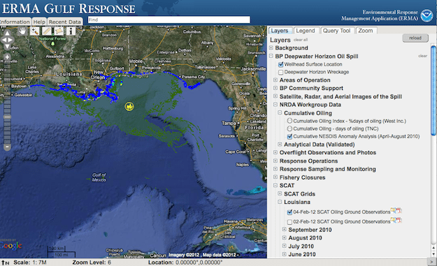
ERMA integrates and synthesizes real-time and static data into a single interactive map, providing a quick visualization of the situation and improving communication and coordination among responders and environmental stakeholders.
NOAA originally began developing Arctic ERMA® to address escalating energy exploration and transportation activity in the region combined with the emerging risk of spills and other accidents.
BSEE is partnering with NOAA to complete the project, with the goal of having the tool available to the response community ahead of any future drilling in federal waters offshore Alaska. When operational, Arctic ERMA® will contain information such as the extent and concentration of sea ice, locations of ports and pipelines, and vulnerable environmental resources for spill responders to make rapid, science-informed response decisions.
The Gulf ERMA was developed through a joint partnership between NOAA and the University of New Hampshire’s Coastal Response Research Center. The Gulf ERMA was designed by NOAA’s Office of Response and Restoration, the University of New Hampshire and the U.S. Environmental Protection Agency.
Since 2007, NOAA and the University of New Hampshire’s Coastal Response Research Center have worked with hazardous material response agencies and partners throughout the United States to develop, test and refine the ERMA® application to meet the needs of various regions. ERMA® sites are also in developmental or testing phases for New England, the Caribbean, Pacific Islands and Pacific Northwest.
The public can view the tool online, which currently covers the Gulf of Mexico region, by visiting http://gomex.erma.noaa.gov/erma.html.
Today’s announcement is part of the ongoing efforts of the Interagency Working Group on Coordination of Domestic Energy Development and Permitting in Alaska, which was established by President Obama in July 2011. Chaired by Department of the Interior Deputy Secretary David J. Hayes, the working group coordinates the efforts of federal agencies responsible for overseeing the safe and responsible development of onshore and offshore energy in Alaska. The group’s goal is to improve the federal government’s efficiency, ensuring that resource development projects in Alaska comply with health, safety, and environmental protection standards while reducing our dependence on foreign oil. For more information, go to: http://www.doi.gov/alaskaenergy
Via BSEE
Unlock Exclusive Insights Today!
Join the gCaptain Club for curated content, insider opinions, and vibrant community discussions.

 Join The Club