Brazilian Air Force and Navy assets are currently being deployed to the crash zone of Air France Flight 447 .
The BBC tells us:
Some oil, a plane seat and other items were sighted 650km (400 miles) north-east of Brazil’s Fernando de Noronha island, the Brazilian air force said.
The find can only be confirmed once the items are retrieved and the first navy boat is not due to arrive until Wednesday.
While it has yet to be confirmed that the debris is from the Airbus, it was spotted in a region of the ocean consistent with its flight path. The jet was heading from Brazil to Paris when it vanished early on Monday.
The mini-subs on the Pourquoi Pas can work at depths of up to 6,000m and the area where the plane disappeared has maximum depths of 4,700m (19,700 ft), French naval experts told AFP news agency.
France is also sending a research ship equipped with two mini-submarines to the search area.
Searchers now planned to focus their efforts on collecting the debris and trying to identify it, the spokesman said.
Col Amaral was also quoted by the Associated Press as saying a life jacket had been spotted amid the debris. “The locations where the objects were found are towards the right of the point where the last signal of the plane was emitted,” he said.
“That suggests that it might have tried to make a turn, maybe to return to Fernando de Noronha, but that is just a hypothesis.”
At least two cargo ships in the area have been asked to go where the debris was found and are expected to arrive soon, Brazilian officials said. Continue Reading…
With the Brazilian Navy not expected to arrive until late Wednesday and aircraft having limited ability to remain in the area with fuel Commercial Vessels in the area are enroute to the scene to initiate the recovery.
gCaptain has confirmed that AMVER (Twitter account @AMVER), the voluntary global ship reporting system used worldwide by search and rescue authorities to arrange for assistance to persons in distress at sea, data has been used to help find and dispatch ships in the area of the crash.
Brazilian media confirms the names of the vessels providing assistance are the Lexa Maersk, Jo Cedar,UAL Texas, Stolt Inspiration with the farthest just 72 kilometers (45 miles) from the crash site.
Flight 447 Crash Maps
This map shows the general location of the crash site estimated to be about 410 miles (650 kilometers) beyond the Brazilian archipelago of Fernando de Noronha.
This is the official Air France drawing showing the flight path of Flight 447 overlaid with the location of the last radar contact.
This map, from the website SailWx.info, shows the VOS ships in the area including the Lexa Maersk, Jo Cedar and UAL Texas. Stay tuned for more information on the vessels providing assistance.
For the latest developments on this story follow @AMVER and @gCaptain on Twitter.
By Maha El Dahan (Reuters) – Iran’s Revolutionary Guards seized an Israeli-linked cargo ship in the Strait of Hormuz on Saturday, days after Tehran said it could close the crucial...
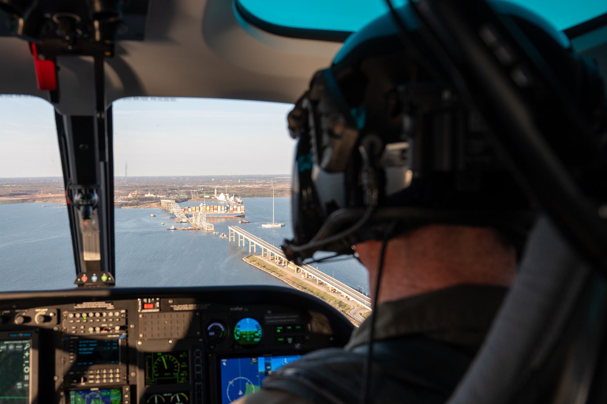
by John Konrad (gCaptain) The Unified Command started clearing debris from the Francis Scott Key Bridge collapse today. They did not specify when they will resume the salvage operation for...
By Jordan Fabian (Bloomberg) President Joe Biden said he will head to Baltimore next week as the US seeks to accelerate emergency work to clear and reconstruct the collapsed Francis Scott...
March 30, 2024
Total Views: 607
Why Join the gCaptain Club?
Access exclusive insights, engage in vibrant discussions, and gain perspectives from our CEO.
This website uses cookies to improve your experience while you navigate through the website. Out of these, the cookies that are categorized as necessary are stored on your browser as they are essential for the working of basic functionalities of the website. We also use third-party cookies that help us analyze and understand how you use this website. These cookies will be stored in your browser only with your consent. You also have the option to opt-out of these cookies. But opting out of some of these cookies may affect your browsing experience.
Necessary cookies are absolutely essential for the website to function properly. This category only includes cookies that ensures basic functionalities and security features of the website. These cookies do not store any personal information.
Any cookies that may not be particularly necessary for the website to function and is used specifically to collect user personal data via analytics, ads, other embedded contents are termed as non-necessary cookies. It is mandatory to procure user consent prior to running these cookies on your website.

 Join The Club