
 Join The Club


USCG
The Harsh Reality of US Coast Guard Migrant Policy
by John Konrad (gCaptain) When merchant and cruise ships rescue migrants at sea, they offer more than just a lifeline from the perilous waters; they provide critical sustenance and care....

A little, Sort Of.
Back on February 1st 2009, though boat owners and ship riders didn’t hear it, there were celebrations all over the rescue world as the COSPAS-SARSAT system stopped processing and reporting 121.5 distress signals. The hours of lost sleep spent chasing after ghost 121.5 EPIRB signals that were actually some other transmitter (like a radio tower or an ATM machine…seriously) is beyond measure. While I appreciated racking up flight hours on the government’s dime; the Coast Guard, along with SAR organizations the world over, have turned a lot of fuel into noise searching for….well…nothing. Only one out of fifty 121.5 alerts have been genuine distress situations. An end to all that warrants at least a little celebration. But even as the date came and went and the chatter about the switch increased – the first problem with the 406 EPIRBs is already showing itself: news release after news release touts the 406 as the “digital” beacon; more powerful, no-waiting, and accurate to just a few yards. The problem is that none of that is completely true – not mostly – and only sort-of. And since recreational boaters and professional mariners are making purchasing decisions about the things, and they are lifesaving devices, I wanted to clear a few things up about the “able-to-leap-buildings-in-a-single bound” 406.
MISNOMER
Most Emergency Position Indicating Radio Beacons do not actually “Indicate” their “Position.” Without an onboard GPS – your EPIRB, any EPIRB, simply transmits a signal that contains the exact same data regardless of where in the world you happen to be. While the position of a non-GPS enabled 406 is calculated with greater accuracy than the old 121.5 beacons – it is done in exactly the same way – by relaying the analog (that’s right – I said it) 406 signal back down to earth for calculation – just like the 121.5s did.
It’s About the Birds
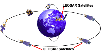
To understand the real benefits of the 406, you really have to understand the satellites they talk to. The COSPAS-SARSAT system is made up two very different types of spacecraft: geosynchronous and low earth orbiting. Geosynchronous (synched up with the geography below them) stay fixed above the equator at specific longitudes – looking straight down at the earth below them from around 22,000 miles high – giving them a very wide look at the earth. Low earth orbiting satellites (LEOSAR) travel around the planet at different rates, and because they fly much lower than their geo-synched brothers (between 500 and 550 miles above the earth), they see a much smaller picture of the surface. If all that seems like too much information – the important points are that one kind of satellite orbits the earth, and the other kind stays fixed in space above it.
One big advantage to the 406 is its ability – with its higher power – to reach out (22,000 miles into space) and be heard by the GEOSAR satellites. You know, the ones way up there above the equator that don’t move and see HUGE pieces of the earth. Positioned around the globe so they can see everything between the 70th parallels – these high fliers are the real engine to the 406 machine. Just as soon as these guys hear that 406 MHz pulse (a half-second long every 50 seconds), encoded with that “digital” information, it immediately retransmits it back down to earth – including the beacon number and your exact latitude and longitude provided by the on-board GPS. The signal also includes your course and speed giving rescuers very accurate – real-time data – to get straight to you.
Without an On-Board GPS – Everything Changes
Without GPS data in the pulse, the GEOSAR Satellites – and all that extra power spent sending them a signal – do nothing. Though they hear the signal, you could be anywhere in their massive window on the world so they have no idea where the beacon is coming from. Your super-digital, high-powered 406 just digressed and the LEOSAR’s do all the work. The position of the beacon is determined by Doppler shift. As the satellite passes over the beacon (and just as with 121.5s, you may have to wait for it) and hears the 406 MHz signal, it retransmits the signal back to earth to one of forty-five Local User Terminal (LUTs) around the earth. Some very serious math is then applied to determine where exactly the beacon is (or was) as the satellite passed overhead. Though much more accurate than the 121.5 signals, and immune to old LEOSAR blind spots, these positions can still be off by as much as 3 miles and may be up to 40 minutes old; older if the satellite picked up the 406 outside the view of a LUT (see map). And while this is way better than the 121.5 accuracy (up to 12 miles off) and timeliness, you should consider the benefits of the on board GPS 406 over the other varieties before making a decision.
What 150 Bucks More Gets You:
I’m not talking about brands; I’m talking about types. So the price difference may be more or less. But given that we are talking about an “emergency” beacon – usually used from the water (meaning your boat is gone) let’s just call the price difference “peanuts”: The difference between a 406 with an on board GPS and one without is best expressed this way. You can let the rescuers know where you are – accurate to within yards and including drift data – every 50 seconds; or you can let the rescuers know where you might have been – accurate to within a few miles – a while ago with a non-GPS 406. Sure, you’ll meet the requirements with the less expensive model, but I promise you won’t miss the extra money sitting (hopefully) in your life raft.
Some readers will notice I haven’t even mentioned the third kind of 406 – the GPS-linked variety that uses data from your vessel’s on-board navigation device. It’s a great idea so long as you’re staying with your vessel, and you’re under power, and the batteries last. How likely is that in an emergency that requires an EPIRB? If you have to abandon ship, or the ship abandons you, the on board navigation system isn’t coming with you….and neither is accurate GPS data.
Bottom Line:
The advantages of global coverage and registration data available with 406 EPIRBS are phenomenal– but consider the following when deciding which type of 406 to purchase:
So all 406’s are not created equal (not even close) – and if you want the fullest digital advantage available and really want to help rescue crews get more sleep, make sure yours has a GPS.
For more information on the COSPAS-SARSAT System, approved devices, proper beacon registration, and more information about digital and analog signal processing than any one person should know – visit www.cospas-sarsat.org
disclaimer: The views and opinions expressed by the author are not necessarily those of the Department of Homeland Security or the U.S. Coast Guard.
Note: This article was first published in February of 2009
Join the gCaptain Club for curated content, insider opinions, and vibrant community discussions.
Join the 105,912 members that receive our newsletter.
Have a news tip? Let us know.
by John Konrad (gCaptain) When merchant and cruise ships rescue migrants at sea, they offer more than just a lifeline from the perilous waters; they provide critical sustenance and care....

by Kevin Hamilton (University of Hawaii) In 2021, an expedition off the icy northern Greenland coast spotted what appeared to be a previously uncharted island. It was small and gravelly,...

by John Konrad (gCaptain) A source close to the investigation has informed gCaptain that Edgar Sison will relinquish his engineering officer license following allegations of sexual assault raised by the...


Access exclusive insights, engage in vibrant discussions, and gain perspectives from our CEO.
Sign Up

Maritime and offshore news trusted by our 105,912 members delivered daily straight to your inbox.
Essential news coupled with the finest maritime content sourced from across the globe.
Sign Up
